The Cíes Islands' Nature and History: Seabirds, Sea Life and Island Life Since the Bronze Age
The Cíes Islands look like a paradise untouched by time: white sand, clear water, pine woods and seabirds. The reality is more interesting. People have lived here, on and off, since the Bronze Age; monks, pirates, soldiers and fish-salters have all left their mark; and the islands’ wild beauty today is the result of decades of deliberate protection. Understanding that story, and the life that fills the cliffs and the sea around them, makes a visit far richer.
This guide covers the national park the islands belong to, their landscape, the seabirds and sea life, their long human history, the other islands of the park, and how to visit in a way that keeps them as they are.
The Atlantic Islands national park
What it protects
The Cíes are part of a maritime-terrestrial national park that takes in four archipelagos off the Galician coast.
- Declared on 1 July 2002, the national park covers 8,480 ha (7,285.2 ha of sea and 1,194.8 ha of land); the Cíes archipelago has 2,658 ha of sea and 433 ha of land.
- The park includes the archipelagos of Cíes, Ons and Cortegada in Pontevedra and Sálvora in A Coruña.
Most of the park is sea: the protected waters around the islands matter as much as the land, and they are covered by the same rules.
How protection grew
The islands were not always so carefully looked after. Mass tourism began in the 1950s, and the damage it caused led to action: protection began in 1980, when Cíes was declared a natural park; it became a Special Protection Area for Birds in 1988. The national park followed in 2002, and with it the daily limit on visitors: the quota is 1,800 visitors a day for the Cíes Islands (1,300 for Ons).
The landscape
Three islands, two faces
The archipelago has three islands, Monteagudo (north), do Faro (middle) and San Martiño (south); the first two are joined by a breakwater and by the sands of Rodas beach. Monteagudo and San Martiño are separated by a strait of about 500 m, the Freu da Porta.
The islands have two very different sides. All three islands are mountainous, with near-vertical western cliffs over 100 m high and many sea caves, while the gentler, sheltered eastern slopes hold woods, beaches and dunes. The west takes the full force of the Atlantic; the east, facing the estuary, is calm enough for beaches to form.
The highest point
The highest point is Alto das Cíes, 197 m, on Monteagudo. From the lighthouses and viewpoints, the islands appear as a single wall against the ocean: at the Cíes lighthouse, 175 m cliffs drop away below you and the whole archipelago is in view, a giant breakwater sheltering the Vigo estuary from the Atlantic.
Rodas and the lagoon
Between Monteagudo and Faro, the sea has built a bar of sand. Rodas beach is 1.3 km long and 60 m wide, and behind it lies a lagoon: at high tide the sea flows between the two islands on the west side and fills the lagoon behind Rodas beach.
Seabirds
The gull colony
The Cíes are one of Europe’s great seabird sites. 22,000 pairs of yellow-legged gulls form the largest colony in the world, and 2,500 pairs of shags also breed here. The gulls dominate the cliffs and slopes; the shags choose ledges close to the sea.
Watching them
There are two bird observatories, near the Pedra da Campá viewpoint and beside the Monteagudo lighthouse. From the one on the lighthouse route, you can watch thousands of nesting yellow-legged gulls and, with luck, shags nesting near the sea. The hides are designed so you can watch without disturbing the colonies. Bring binoculars if you have them, be patient, and speak quietly: the longer you watch, the more you notice.
A warning from the past
Not every species has fared well. In 1960, 400 pairs of Iberian guillemots were counted; the species is now almost extinct on the islands.
Life in the sea
The waters around the Cíes are part of the national park and full of life.
- Visitors from the ocean. Dolphins, whales and sea turtles regularly visit the waters around the islands. Watch from the boat and the high viewpoints.
- The lagoon. On clear days, fish, crabs and seaweed can be seen from the dyke across O Lago.
- Protection. Spearfishing and sport fishing are forbidden, and scuba diving with weights needs prior permission. Collecting shells from the beaches or seabed is not allowed.
Plants of the dunes
Behind the beaches, the dunes shelter plants adapted to salt, wind and shifting sand, some of them rare. The endangered sea thrift, Armeria pungens, is among the treasures of the Galician-Portuguese coast found here. Walking only on the marked paths across the dunes is the simplest way to protect them.
Island life since the Bronze Age
The first islanders
The first settlement dates from the Bronze Age: the village of As Hortas on the slope of Monte Faro, also occupied in Roman times. Finds show that the Bronze Age islanders ate shellfish and fish from nearby waters and probably traded with people on the coast. Near the top you can detour to the castro of As Hortas, the remains of a Bronze Age settlement, on the lighthouse route.
The Islands of the Gods
The Romans called them the Islands of the Gods. It is easy to see why, standing on Monte Faro with the Atlantic spread out below.
Hermits and monks
In the early Middle Ages, religious communities sought the islands’ isolation. In the 6th century two hermitages were founded, San Martiño on the south island and San Estevo on the middle island, on whose ruins the interpretation centre now stands.
The interpretation centre
Today the site of San Estevo holds the park’s interpretation centre. The interpretation centre has an exhibition on the park’s values, and history is still visible there: one of the anthropomorphic tombs found at San Estevo can still be seen at the interpretation centre. It lies on the lighthouse route, about 20 minutes from the information hut, so it is easy to include in a walk.
Pirates
Isolation also brought danger. The islanders left in the mid-16th century because of pirate raids, Francis Drake’s among them. For long periods the islands were almost deserted.
Soldiers and settlers
Security returned in the 19th century. In the 19th century the islands were fortified: an artillery store was set up in 1810 in the old San Estevo monastery, with a barracks and a jail near Nosa Señora beach, which encouraged people to resettle.
Salt fish and a lighthouse
With settlers came industry. Around 1840 two fish-salting factories were built, one where the Rodas restaurant now stands, and the lighthouse dates from 1852. A tavern stood near the lake, which was used as a lobster nursery. But the business did not last: competition from the canneries on the nearby coast brought the salting factories down, and by 1900 they were reduced to stores.
The last islanders
A small population, mostly from Cangas, lived on the islands until the mid-20th century. As they left, the visitors arrived, and the modern story of the islands — tourism and protection — began. Walking the paths today, you pass the traces of every chapter: the Bronze Age village on Monte Faro, the hermitage ruins beneath the interpretation centre, the dyke and the lighthouse of the 19th century, and the site of the old salting factory by Rodas. Few beaches anywhere carry so much history so lightly.
The other islands of the park
The Cíes share the national park with three other archipelagos, each with its own character.
- Ons has a similar permit system. Ons is the only one of the Atlantic Islands that still has a stable population, of fewer than 20 people.
- Sálvora has a dramatic history: in 1921 the steamer Santa Isabel was wrecked off Sálvora; islanders, mostly women, rowed out to help, but more than 200 people died.
- Cortegada has a spiritual past: in the 14th and 15th centuries the sanctuary on Cortegada drew great pilgrimages.
A day for nature lovers
- Early boat: arrive with the first crossing, when the islands are at their quietest.
- Lighthouse route: walk to the bird observatory near Pedra da Campá and on to the lighthouse, stopping at the interpretation centre on the way.
- As Hortas: the short detour to the Bronze Age village near the top.
- Lunch: a picnic in a rest area by the lagoon.
- Afternoon: the lagoon at high tide, then a slow walk along Rodas and the dunes, keeping to the paths.
- Crossing home: watch the water for dolphins from the deck.
Wildlife etiquette
- Keep your distance from nesting birds, which are easily disturbed.
- Use the observatories, which are designed to let you watch without disturbing the colonies.
- Never feed the gulls, and keep food packed away on the beach.
- Stay on the paths, especially across the dunes and near the cliffs.
- Leave everything as you found it: shells, stones and plants stay on the islands.
Beaches shaped by the Atlantic
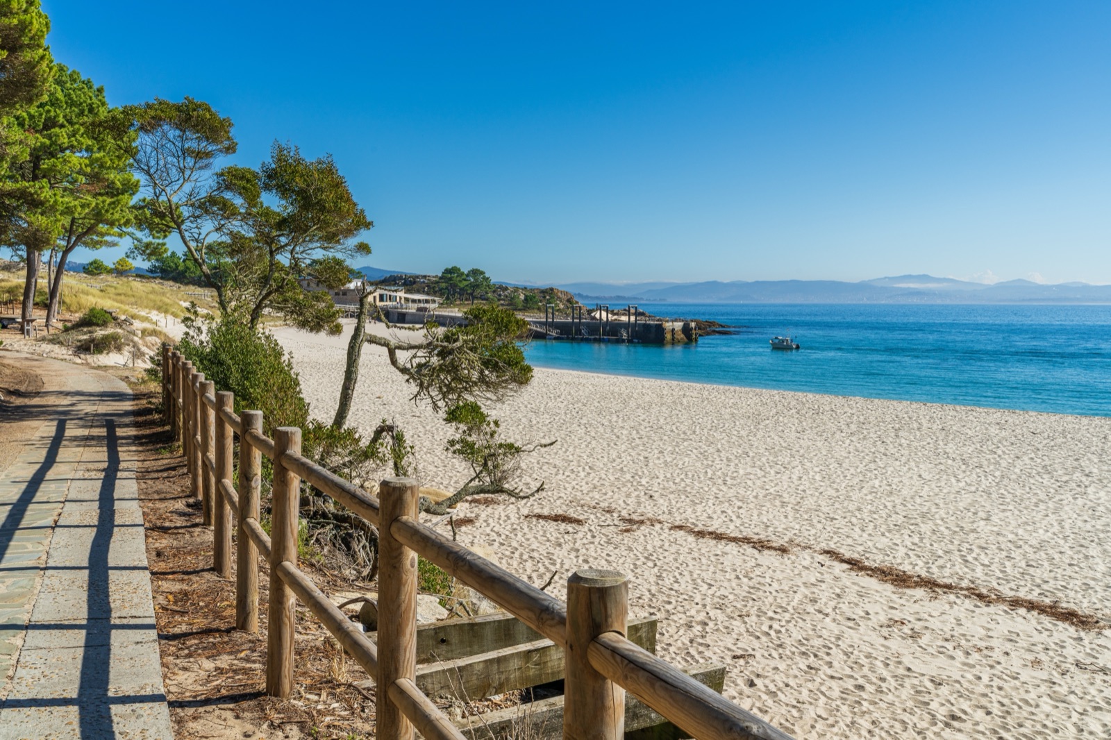
The beaches are a product of the islands’ shape. Facing the estuary, sheltered from the ocean by the islands themselves, the eastern shores collect sand into beaches and dunes. The archipelago has nine beaches in all, and Rodas is the most visited beach in Galicia; in February 2007 The Guardian named Rodas ‘the best beach in the world’. The same shelter that creates the beaches makes the water inside the islands calm enough for the lagoon to form behind Rodas.
Visiting responsibly
The rules of the national park exist to protect everything described in this guide.
- Leaving rubbish of any kind is forbidden. There are no bins to rely on; take everything home.
- Fires of any kind are forbidden, as is camping outside the campsite.
- Pets may not be landed, except guide dogs.
- Only walking is allowed on the paths; bicycles and other vehicles are not.
- Drones and kites need express permission from the national park.
- Loudspeakers and noise that disturbs the natural peace are not allowed.
- Keep to the paths, especially near nesting gulls and across the dunes.
Facilities for visitors
Being a national park, the islands have only the basics.
- There is no drinking water: the public fountains have no health guarantee, so bring water, though it can be bought at the islands’ eateries.
- Public toilets are on the path above the campsite, on the lighthouse route.
- A first-aid point operates only in high season, at the campsite, and Vigo usually provides beach lifeguards in summer; staff arrive on the first boat and leave on the last.
- The campsite is on Faro island, passed on the way to the lighthouse.
When to visit
- High season (Holy Week and 15 May–15 September) brings the warmest weather and the busiest beaches, and the free permit is required. The gull colonies are busiest in the breeding season.
- Out of season, visits to Cíes and Ons are made in guided groups, with a guide to explain the islands’ nature and history — an excellent way to learn more.
- At any time, the Atlantic sets the rules: boats depend on the sea and the weather.
Getting there in brief
In high season (Holy Week and 15 May–15 September) each visitor needs a free permit from the Xunta before travelling, because the islands have a daily visitor limit. Boats to the Cíes leave from Vigo, Cangas, Baiona, Sanxenxo and Portonovo, and crossings take about 40 minutes from Vigo, 35 minutes from Baiona and about an hour from Cangas (calling at Vigo), Sanxenxo and Portonovo. Apply for the permit first; the pre-booking code it gives you lasts two hours, and you need it to buy the ferry ticket.
Photographing wildlife and landscapes
- Seabirds: use the observatories and a long lens; getting closer disturbs the colonies and rarely improves the picture.
- The cliffs: the western side is best seen from the lighthouse and the viewpoints, never from the cliff edge.
- The lagoon: at high tide the water fills it, and on calm, clear days the life beneath the surface is easy to see.
- The ruins: As Hortas and the tomb at the interpretation centre reward a closer look.
- From the boat: the crossing gives the best views of the islands as a whole, and the best chance of dolphins.
Seeing the islands from the water
Full-day sailing trip with a skipper. A sailboat from Vigo with a picnic on board, snorkelling and paddleboarding, anchoring off the islands so you can walk to the lighthouse. About 8 hours — a chance to see the cliffs and the sea life from the water.
Round-trip boat from Vigo or Cangas. The return boat to the islands, with the day on the islands yours. About 5–6 hours.
The tours page lists them all with live prices. For permits and ferries, see how to visit the Cíes Islands; for routes, walks and beaches.
Frequently asked questions
When did the Cíes Islands become a national park?
The Atlantic Islands of Galicia national park was declared on 1 July 2002. The Cíes had been a natural park since 1980.
What birds live on the Cíes Islands?
Above all yellow-legged gulls — 22,000 pairs, the largest colony in the world — and 2,500 pairs of shags.
Did people ever live on the Cíes Islands?
Yes. The first settlement, As Hortas, dates from the Bronze Age. Hermits lived there from the 6th century, and a small population, mostly from Cangas, remained until the mid-20th century.
Can you see dolphins at the Cíes Islands?
Dolphins, whales and sea turtles regularly visit the waters around the islands.
When was the Cíes lighthouse built?
The lighthouse dates from 1852.
How big are the Cíes Islands?
The Cíes archipelago has 433 ha of land and 2,658 ha of sea within the national park, and its highest point, Alto das Cíes, is 197 m.
Can I visit the other islands of the park?
Yes. Ons has a similar permit system and a quota of 1,300 visitors a day; the islands of Sálvora and Cortegada are also part of the park.